
2谷歌地图相互冲突
2谷歌地图相互冲突
提问于 2014-08-06 16:58:47
我正在创建一个web应用程序,它有两个Google实例:一个有多个点,另一个只有一点。
它们似乎相互冲突,因为当我先看一页时,另一张地图的中心位置就不对了。
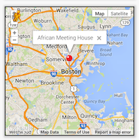
首页:
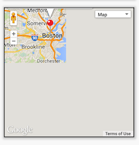
第二页:
下面是我的项目的链接:http://jakeserver.com/Apps/BostonLandmarks/B12/index.html
下面是生成Google地图的代码:
var detailsMap = new google.maps.Map(document.getElementById("map_" + this.id), {
  zoom: 10,
  center: new google.maps.LatLng(landmarkList[rowCount].landmarkGPSNorth, landmarkList[rowCount].landmarkGPSWest),
  mapTypeId: google.maps.MapTypeId.ROADMAP
});

var detailsInfoWindow = new google.maps.InfoWindow();

var detailsMarker, j;

detailsMarker = new google.maps.Marker({
  position: new google.maps.LatLng(landmarksArray[rowCount].landmarkGPSNorth, landmarksArray[rowCount].landmarkGPSWest),
  map: detailsMap,
  icon: "Icons/red-pin.pdf"
});
detailsInfoWindow.setContent(landmarksArray[rowCount].landmarkName);
detailsInfoWindow.open(detailsMap, detailsMarker);

google.maps.event.addListener(detailsMarker, 'click', (function(detailsMarker, j) {
  return function() {
    detailsInfoWindow.open(detailsMap, detailsMarker);
  }
})(detailsMarker, j));
}

document.getElementById("map_" + this.id).style.height = 300 + "px";
document.getElementById("map_" + this.id).style.width = 300 + "px";
有什么想法吗?
回答 1
Stack Overflow用户
回答已采纳
发布于 2014-08-06 17:21:55
很久以前,我在一个网站中使用基于Ajax的导航时遇到了类似的问题,每个页面都有一张地图,第一个页面正常工作,但是下一个页面有相同的问题。
在显示地图之前,您应该创建一个新的绑定对象。就像这样:
var bounds = new google.maps.LatLngBounds();在那之后。你必须扩大边界,通过你的标志位置。如下所示:
bounds.extend(marker.position);最后,当地图实际上是可见的和呈现的时候。运行以下行。
google.maps.event.trigger(secondMapInstance, 'resize');
secondMapInstance.fitBounds(bounds);页面原文内容由Stack Overflow提供。腾讯云小微IT领域专用引擎提供翻译支持
原文链接:
https://stackoverflow.com/questions/25166019
复制相关文章
相似问题
腾讯云开发者

Copyright © 2013 - 2026 Tencent Cloud. All Rights Reserved. 腾讯云 版权所有
深圳市腾讯计算机系统有限公司 ICP备案/许可证号:粤B2-20090059 ![]() 粤公网安备44030502008569号
粤公网安备44030502008569号
腾讯云计算(北京)有限责任公司 京ICP证150476号 | 京ICP备11018762号